JAGO awarded for DataMan mapping system
The DataMan geographic system, developed by the MOD's Joint Aeronautical and Geospatial Organisation (JAGO), has been recognised as one of 2011's top five programmes and innovations in the ISR (Intelligence, Surveillance and Reconnaissance) community.
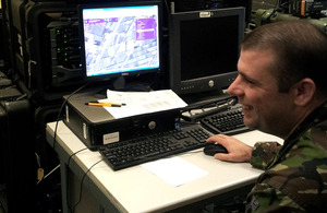
Staff Sergeant Antony Giles developed the GeoViewer application, which provides a secure user interface through which to access the geospatial information collected by DataMan [Picture: Crown Copyright/MOD 2011]
At the C4ISR (Command, Control, Communications, Computers, Intelligence, Surveillance and Reconnaissance) Journal’s Annual Conference and Awards Ceremony, held in Washington DC in October, DataMan won the Network Systems Award. The top programmes and innovations are selected from five categories: Platforms, Sensors, Organisations, Innovations and Network Systems.
DataMan is connected to the UK military’s secure network in Afghanistan and delivers a common geospatial picture via a secure online browser called GeoViewer. It brings together a huge range of otherwise disparate data from multiple sources, the common factor being location. It also delivers geospatial information directly into other Command and Control (C2) and Intelligence applications on the OVERTASK network.
In March 2010, DataMan was successfully deployed in Afghanistan, operated by 42 Engineer Regiment (Geographic), and, within nine months, was receiving over two million hits per month from a wide range of users throughout the command chain.
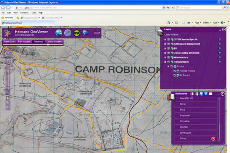
A sample screenshot of GeoViewer displaying geospatial data collated by DataMan [Picture: Crown Copyright/MOD 2011]
For the first time, JAGO is able to ensure that everyone, from geospatial analysts to patrols on the ground just requiring a map, are referring to the same, accurate pool of current information and intelligence. The system uses Esri’s ArcGIS, a standards-based, commercially available off-the-shelf geospatial information software package. Staff Sergeant Antony Giles, Capability Development SSgt and GeoViewer developer, said the wide use of the GeoViewer web application came as something of a surprise:
We originally developed it as a tool for users to view geospatial information and products prior to requesting data. However, it quickly became the visualisation tool of choice for hundreds of Op HERRICK users who wanted easy access to situational awareness information.
Ben Iannotta, Editor of the C4ISR Journal, stated the reason for DataMan’s nomination was based around its rapid acquisition and simplicity:
The ability for troops to view information from multiple sources in a geospatial context is crucial for their decision-making and JAGO figured out how to provide this capability, quickly, by using existing software as much as possible. They innovated, but with the discipline not to reach too far.
DataMan currently integrates over more than 300 layers of data, including information and intelligence from satellite and aerial reconnaissance, ground patrols and partners working in the same regions. Information that was previously held by external organisations in spreadsheets - for example, lists of medical facilities in Afghanistan - can now be loaded once into DataMan, visualised in a geographic context, and made accessible to all units and partners working in the vicinity:
This significant award underlines both JAGO’s foresight in developing DataMan, and its achievement in bringing this new capability so quickly into theatre where it has been so well received,” commented Budgie Dhanda, General Manager, Defence and National Security, Esri UK.
On receiving the award Mr Keith Mosley, JAGO’s Capability Development technical lead and DataMan designer, said:
We have been developing this system for over five years now, and to see it successfully providing authoritative geospatial information and situational awareness overlays to users on Op HERRICK is very satisfying.